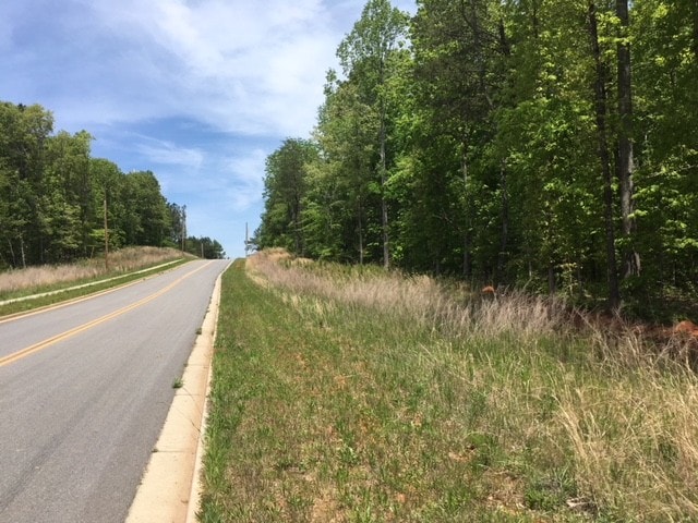
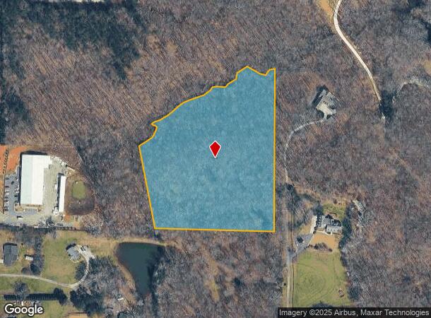
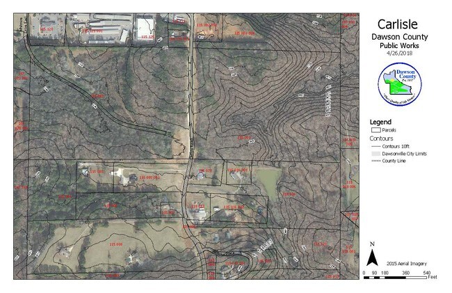
Property Record
222 Carlisle Rd, Dawsonville, GA 30534
NEARBY LISTINGS FOR SALE OR LEASE
-
-
-
-
-
-
-
-
-
-
No Photo
-
-
View all Dawsonville listings for sale on LoopNet.com
Property Detail
222 Carlisle Rd
Atlanta-Sandy Springs-Roswell, GA
Chuck & Mary Colson
115-000-001-000
LL 472 LD 13-S
Residentialacreage
Dawson
X
Georgia
13117C0060G
472
2024
9.47 AC
2024
Dawson County
970206
Atlanta
DEMOGRAPHICS near 222 Carlisle Rd
1 Mile
3 Mile
5 Mile
2024 Total Population
1,745
19,011
42,176
2029 Population
2,301
23,976
51,917
Pop Growth 2024-2029
+ 31.86%
+ 26.12%
+ 23.10%
Average Age
41
40
40
2024 Total Households
712
6,823
14,910
HH Growth 2024-2029
+ 31.88%
+ 26.44%
+ 23.47%
Median Household Inc
$78,309
$101,812
$103,461
Avg Household Size
2.40
2.70
2.80
2024 Avg HH Vehicles
2.00
2.00
2.00
Median Home Value
$355,084
$356,970
$368,743
Median Year Built
2004
2002
2003
Nearby Places
Map Layers
Map Styles
 Street
 Aerial
- Restaurants
- Banks
- Shops
- Fitness
- Groceries
SALE & LEASE HISTORY
LISTING DATE
SALE/LEASE

May 08, 2018
For Sale
Dec 15, 2023
For Sale
Nearby Properties
Address
Land Use
TOTAL SIZE
Lot Size
Zoning
Address
Land Use
TOTAL SIZE
Lot Size
Zoning
70,312 SF
61.79 AC
C-HB
Address
Land Use
TOTAL SIZE
Lot Size
Zoning
12,090 SF
21.69 AC
C-PCD
Address
Land Use
TOTAL SIZE
Lot Size
Zoning
24,092 SF
40 AC
RA
Address
Land Use
TOTAL SIZE
Lot Size
Zoning
4,872 SF
23.09 AC
RMF
Address
Land Use
TOTAL SIZE
Lot Size
Zoning
57,666 SF
19.39 AC
Address
Land Use
TOTAL SIZE
Lot Size
Zoning
93,514 SF
30.24 AC
Address
Land Use
TOTAL SIZE
Lot Size
Zoning
122,225 SF
14.72 AC
C-HB
Address
Land Use
TOTAL SIZE
Lot Size
Zoning
6,086 SF
14.85 AC
O&I
Address
Land Use
TOTAL SIZE
Lot Size
Zoning
197,360 SF
24.24 AC
C-PCD
Address
Land Use
TOTAL SIZE
Lot Size
Zoning
23,424 SF
18.33 AC
C-HB
Address
Land Use
TOTAL SIZE
Lot Size
Zoning
83,774 SF
12.32 AC
Q
Address
Land Use
TOTAL SIZE
Lot Size
Zoning
35,786 SF
1.96 AC
C-PCD
Address
Land Use
TOTAL SIZE
Lot Size
Zoning
8,155 SF
1.28 AC
C-PCD
Address
Land Use
TOTAL SIZE
Lot Size
Zoning
54,674 SF
7.65 AC
UV
Address
Land Use
TOTAL SIZE
Lot Size
Zoning
84,304 SF
19.76 AC
C-PCD
Address
Land Use
TOTAL SIZE
Lot Size
Zoning
99,044 SF
10.60 AC
C-HB
Address
Land Use
TOTAL SIZE
Lot Size
Zoning
2,064 SF
5.40 AC
C-HB
Address
Land Use
TOTAL SIZE
Lot Size
Zoning
119,116 SF
17.01 AC
C-PCD
Address
Land Use
TOTAL SIZE
Lot Size
Zoning
23,625 SF
6.31 AC
C-HB
Address
Land Use
TOTAL SIZE
Lot Size
Zoning
9,826 SF
10.16 AC
RMF
Address
Land Use
TOTAL SIZE
Lot Size
Zoning
39,251 SF
109.39 AC
A1
Address
Land Use
TOTAL SIZE
Lot Size
Zoning
64,729 SF
20.01 AC
RA
Address
Land Use
TOTAL SIZE
Lot Size
Zoning
25,284 SF
1.47 AC
C-PCD
Address
Land Use
TOTAL SIZE
Lot Size
Zoning
69,903 SF
19.99 AC
RA
Address
Land Use
TOTAL SIZE
Lot Size
Zoning
53,284 SF
1.43 AC
C-HB
Address
Land Use
TOTAL SIZE
Lot Size
Zoning
352.69 AC
C-0I
Address
Land Use
TOTAL SIZE
Lot Size
Zoning
45,449 SF
10.76 AC
C-IR
Address
Land Use
TOTAL SIZE
Lot Size
Zoning
70,743 SF
11.41 AC
Q
Address
Land Use
TOTAL SIZE
Lot Size
Zoning
37,784 SF
8 AC
C-HB
Address
Land Use
TOTAL SIZE
Lot Size
Zoning
174,860 SF
17.82 AC
C-IR
The World's #1 Commercial Real Estate Marketplace
Connect with us
© 2025 CoStar Group
The information above has been obtained from sources believed reliable. While we do not doubt its accuracy we have not verified it and make no guarantee, warranty or representation about it. It is your responsibility to independently confirm its accuracy and completeness. Any projections, opinions, assumptions, or estimates used are for example only and do not represent the current or future performance of the property. The value of this transaction to you depends on tax and other factors which should be evaluated by your tax, financial, and legal advisors. You and your advisors should conduct a careful, independent investigation of the property to determine to your satisfaction the suitability of the property for your needs.